
Download Data
Water Depletion and WaterGap3 Basins
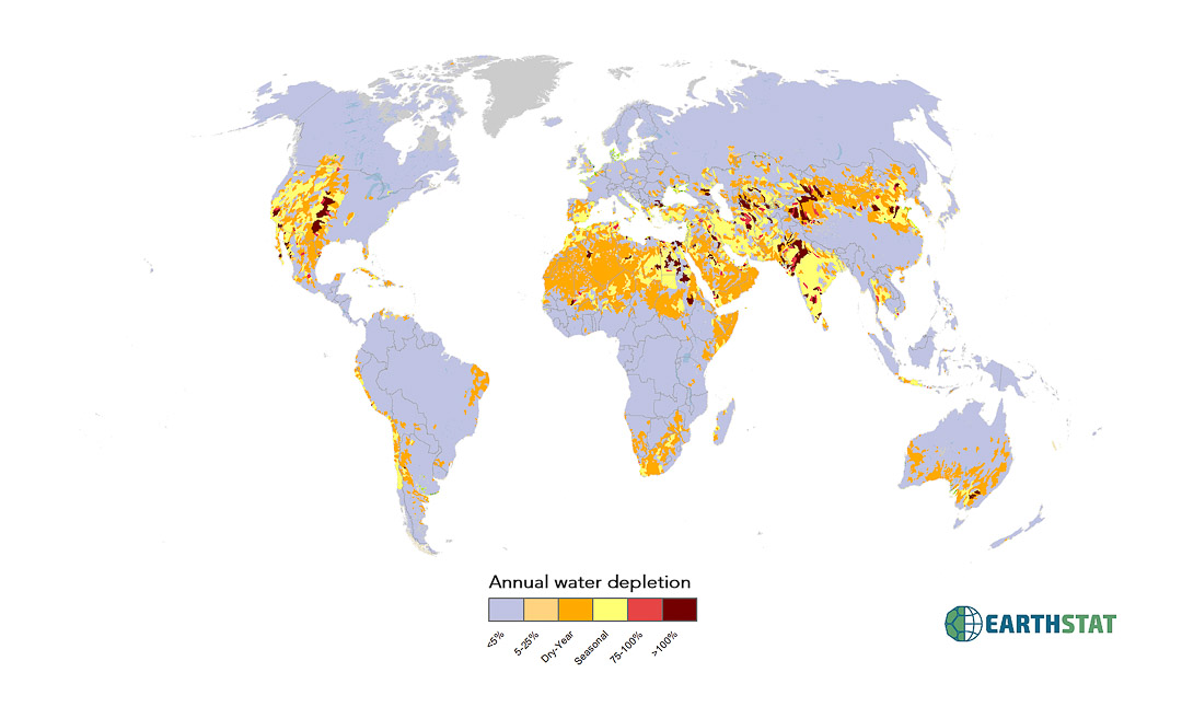
Water depletion is a measure of the fraction of available renewable water consumptively used by human activities within a watershed. Our characterization of water depletion uses calculations from WaterGAP3 to assess long-term average annual consumed fraction of renewably available water, then integrates seasonal depletion and dry-year depletion, also based on WaterGAP3 calculations, with average annual depletion into a unified scale. There are 8 water depletion categories: <5% depleted, 5-25% depleted, 25-50% depleted, 50-75% depleted, dry-year depleted, seasonally depleted, 75-100% depleted, and >100% depleted. For data reliability reasons, we include only the 15,091 watersheds larger than 1,000 km2, which constitute 90% of total land area. A large number of small coastal watersheds are excluded. Detailed information can be found in the open-access paper “Water Depletion: An improved metric for incorporating seasonal and dry-year water scarcity into water risk assessments” online at Elementa: Science of the Anthropocene < http://elementascience.org/>
Citation:
Brauman, KA, BD Richter, S Postel, M Malby, M Flörke. (2016) “Water Depletion: An improved metric for incorporating seasonal and dry-year water scarcity into water risk assessments.” Elementa: Science of the Anthropocene. Doi: http://doi.org/10.12952/journal.elementa.000083
Contact:
Direct questions by email to earthstat.data@gmail.com or kate.brauman@umn.edu
For additional information regarding publications and research, visit http://www.watergap.de/ or http://environment.umn.edu/research-solutions/global-water-initiative/
Data Products:
The following data products are included:
WaterGAP 3 basins (shapefile)
- Annual water depletion categories
- <5%
- 5-25%
- Dry-Year
- Seasonal
- 75-100%
- >100%
- ContUID : Continent-based unique basin ID
- SubBas_ID: Unique basin ID, by continent (not globally unique)
Annual water depletion (geotiff)
Annual water depletion categories
1= <5%
2= 5-25%
5= Dry-Year
6= Seasonal
7= 75-100%
8= >100%
Resolution:
- Geotiff: Five-arc-minute by five-arc-minute resolution (~10km x 10km at equator)
- Shapefile contains 15,084 feature basins. Basins of area smaller than 1,000 km2 were omitted from this study, and are not included.
Map Projection:
- Data presented as five-arc-minute, 4320 x 2160 cell grid
- Spatial Reference: GCS_WGS_1984
- Datum: D_WGS_1984
- Cell size: 0.083333 degrees
- Layer extent:
- Top : Geotiff: 90, Shapefile: 83.249970
- Left: Geotiff: -180, Shapefile: -179.916667
- Right: Geotiff: 180, Shapefile: 179.999856
- Bottom: Geotiff: -90, Shapefile: -54.833289
License:
Creative Commons Attribution 4.0 International
Data may be freely downloaded for research, study, or teaching, but must be cited appropriately. Re-release of the data, or incorporation of the data into a commercial product, is allowed only with explicit permission. If you would like to request permission to use EarthStat data for another purpose, please contact us at earthstat.data@gmail.com.